A bit of history
“Alfred Métraux (The Incas. Editions du Seuil): The term Inca is ambiguous and, in common usage, has drifted away from its original meaning: chief. The ruler of Peru was the Inca par excellence, a title also granted to members of his family and lineages related to him. [...] Today, this word, both noun and adjective, refers to everything connected with the history or civilization of the Inca dynasty. It is notably applied to the people over whom it ruled. [...]
It was the name Quechua that missionaries gave to runa-simi, the language of men, and that name is still used today for the Indians who speak it. [...] The history of Peru's Indians therefore has two periods: that of the Incas proper, which ends in the 16th century, and that of the Quechuas, which continues before our eyes [...].
Milestones in Inca history in table form
| Dates | Milestones |
|---|---|
| 15,000 to 5,000 BCE | Lithic period -10,000 traces of life in Peru (rock paintings, arrowheads...) - 6,000 sedentarization and animal domestication (llama) |
| 5000 to 1800 BCE | Archaic period - 2,500 intensive agriculture and arrival of irrigation techniques - 1,800 pottery production |
| 1800 to 500 BCE | Formative period - 1,800 to 1,200: early formative. Farming villages. First metal objects - 1,200 to 500: late formative. Development and spread of Chavin culture. |
| 500 BCE to 700 CE | Regional development period. Following the decline of Chavin civilization, regional cultures grew in the south: Mochina on the north coast, Lima on the central coast, Nazca on the south coast, Tiahuanaco near Lake Titicaca. |
| 500 to 1000 CE | Wari Empire. In the southern Sierra, Wari culture (Ayacucho basin) rose and influenced most of the country before gradually fading, together with the city of the same name. |
| 1000 to 1450 | Regional states period. Formation of local states around major urban centers |
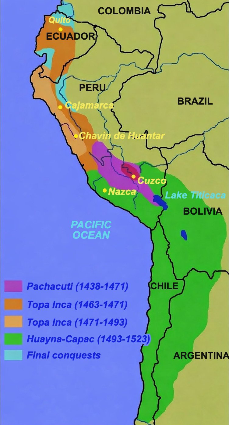
| Around 1200 CE | Beginning of the Inca state. Foundation of the capital: Cuzco |
| 1200 to 1438 | Reign of the semi-legendary Incas: Manco-Capac, Sinchi-Rocha, Lloque Yupanqui, Mayta-Capac, Capac-Yupanqui, Inca-Roca, Yahuar-Huaca, Viracocha-Inca. |
| 1438 - 1471 | Reign of Pachacuti-Inca Yupanqui |
| 1471 - 1493 | Reign of Topa-Inca Yupanqui |
| 1493 - 1527 | Reign of Huayna-Capac |
| 1527 | Pizarro lands at Tumbez and discovers the Inca Empire. |
| 1531 - 1532 | Pizarro's third expedition and occupation of Tumbez |
| June 1532 | Pizarro founds the first Spanish city in Peru, San Miguel (now Piura) |
| 1533 | Assassination of Huascar on Atahualpa's orders. |
| 29 August 1533 | Execution of Atahualpa after payment of his ransom. "In this kingdom, no bird flies, no leaf moves, unless I will it." So spoke Atahualpa, the last Inca emperor, shortly before being killed by the Spanish conquerors. |
| 15 November 1533 | Entry of the Spaniards into Cuzco. |
| 1536 | Uprising of Manco-Capac II and siege of Cuzco |
| 1537 | Manco-Capac takes refuge in the mountains of Vilcabamba and founds a new Inca state. |
| 1545 | Manco-Capac is assassinated by the Spaniards. |
| 1572 | Conquest of the Inca kingdom of Vilcabamba and capture of Inca Tupac-Amaru, who is executed the same year. |
| 1572 | Viceroy Francisco de Toledo gives Peru a new social and political structure. |
| ... | ... |
| 1975 | President Velasco Alvarado makes Quechua an official language in Peru |
| 1979 | The constitutional charter repeals that decree. |
A few definitions
Let us end this section with a few definitions that will be useful for understanding the Inca calendar better. I thank Daniel Duguay for sharing them with me.
Ayllu
A very old Peruvian social institution grouping an agrarian community bound by kinship, blood ties, neighbourhood, religion and language (usually around 200 to 300 people per ayllu). These ties were also economic, since all members contributed work through a cooperative system, the ayni, on commonly owned land (marka in Quechua).
The ayllu system originated in small Andean farming communities that predated the Incas. The Incas, who emerged from those communities, adapted and strengthened it to fit their mode of government. The Inca himself lived in an ayllu (the royal panaca). This type of social organization survived Spanish extractions from indigenous communities and coexisted, throughout the colonial period, with the harsh encomienda regime.
There are still nearly 5,000 Andean ayllus in Peru carrying out farming work, construction and maintenance of communal granaries, roads, bridges, etc., in common.
Huaca or Guaca
In pre-Hispanic Peru, this referred to any object or place imbued with supernatural force and requiring worship. By extension, the word now applies to ruins, ancient dwellings, and even pottery (huacos) found in tombs. Huaqueros are tomb looters.
Panaca
This Quechua word may be translated as “lineage” or “kinship.” The Incas had a double, or rather parallel, filiation system that may seem unusual to us: within the ayllu, there was patrilineal and matrilineal descent; that is, men were apparently considered descendants of their father only, and women of their mother.
As for the family proper, smaller than the wider community, its ties were naturally tighter. Yet the names given to family members were not the same depending on whether they came from men or women. A mother used the same term for her children of different sexes, while a father distinguished son from daughter, though he also called other relatives “son,” such as nephews. The terms “brother” and “sister” were often used for first cousins. It even happened that an Indian used the terms “father, mother, brother, sister” for more distant relatives.
A proper understanding of what the panaca was helps avoid the error made by chroniclers who claimed, for example, that the supreme Inca could have married his elder sister.
Sucanca
Stone pillars erected to the east and west of Cuzco, used to indicate the Sun's position (at sunrise and sunset) at the solstices. The beginning of winter was indicated by a Pucay Sucanca and the beginning of summer by a Chirao Sucanca.
Ushnu
A stone marker used as an observation point, from which one “sights” a sucanca or another reference point. In Cuzco itself, the ushnu stood on the Huacaypata (the main square).
Calendar(s)
Difficulties
The main difficulty in reconstructing the Inca calendar is that the Incas did not know writing. At least not writing as we know it today, nor even a logosyllabic writing system like that of the Maya.
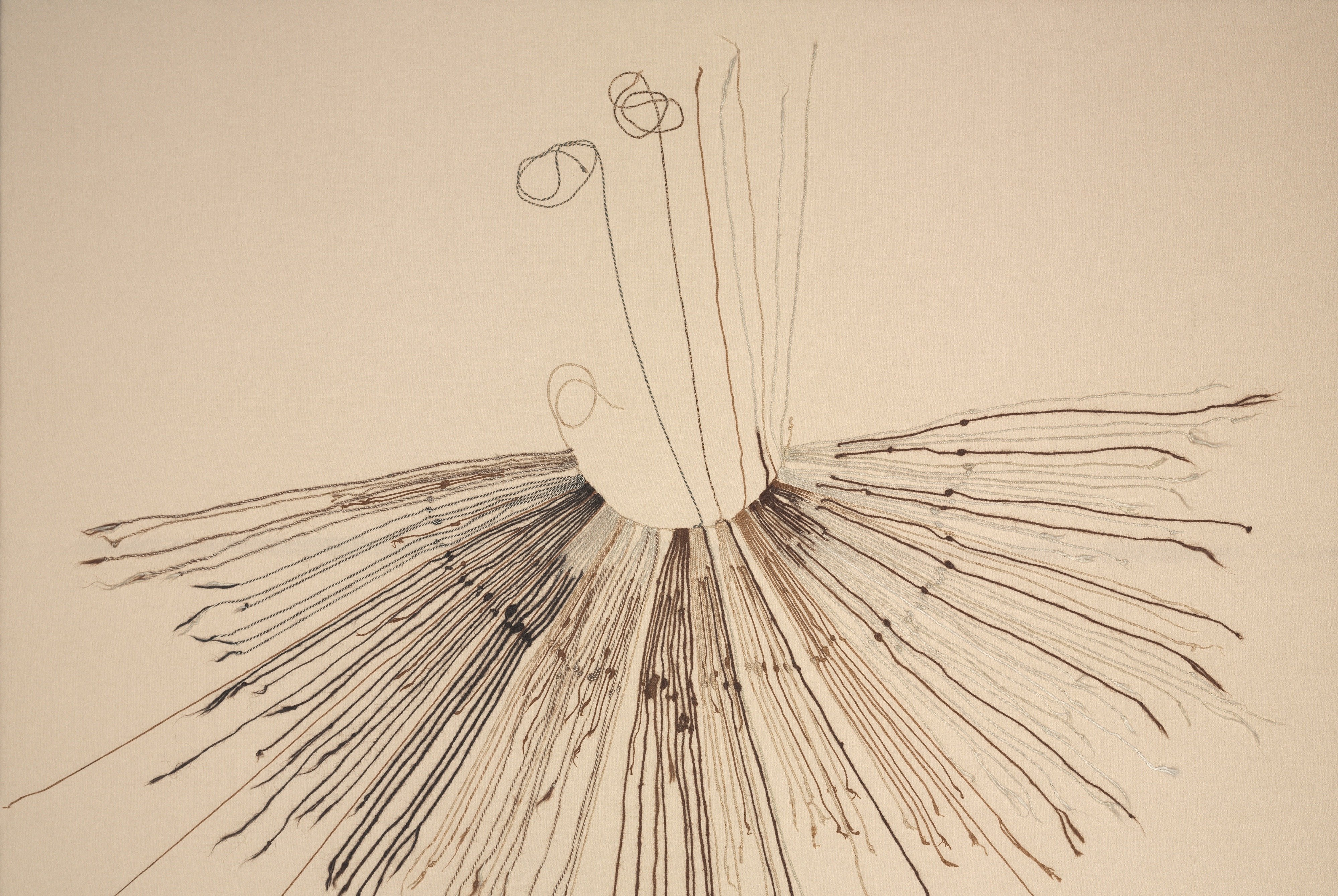
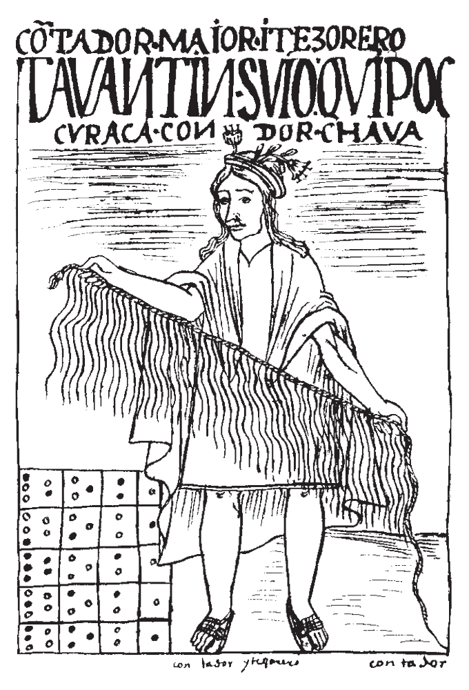
That did not stop them from storing an almost cyclopean amount of information. To do so, they used the quipu (quipo, quipou), an arrangement of cords whose knots, colors and numbers were used for calculation and data storage.
It would be surprising if these quipus contained no calendar data. The problem is that we are not “Quipu camayo” (a person tasked with using quipus), and the mysteries of these “documents” remain mysteries. All the more so because only the author of a quipu was truly able to decipher it.
An anecdote told by Bernabé Cobo [1582-1687] gives an idea of quipus' storage power: a Spaniard, traveling from one city to another, was assigned a guide at a “road relay.” He never reached his destination, and his body was found six years later. He had been murdered. But by whom? Who was the guide who accompanied him? The quipu camayos were called in, and one of them found the guide's name in his quipu. The guide was questioned and confessed to the murder.
In the absence of readable writing, the Incas left us monuments and sacred places (huacas). But here too there is a problem, due to their destruction by the Spaniards during the conquest (and later) of the Inca Empire. In the name of Christianity and evangelization, they destroyed those places of supposed idolatry. As can also be seen with the Inuit calendar, Christianity is often synonymous with stupidity.
So, to get an idea of the Inca calendar, we are mostly left with:
1) writings by post-conquest chroniclers such as Bernabé Cobo (1582-1687), a Spanish priest who lived 61 years in South America; Felipe Guaman Poma de Ayala (1538?-1620?), himself partly Inca and author of a massive illustrated work; Garcilaso de la Vega (1539 - ?), born in Cuzco; and many others listed here on a very good site (in French), where one can also find a dictionary of the Incas and itinerary advice.
2) hypotheses put forward by contemporary researchers such as Anthony Aveni or R. Tom Zuidema, among others.
We will therefore explore chroniclers' writings and modern hypotheses. Naturally, at times, the former are illuminated by the latter.
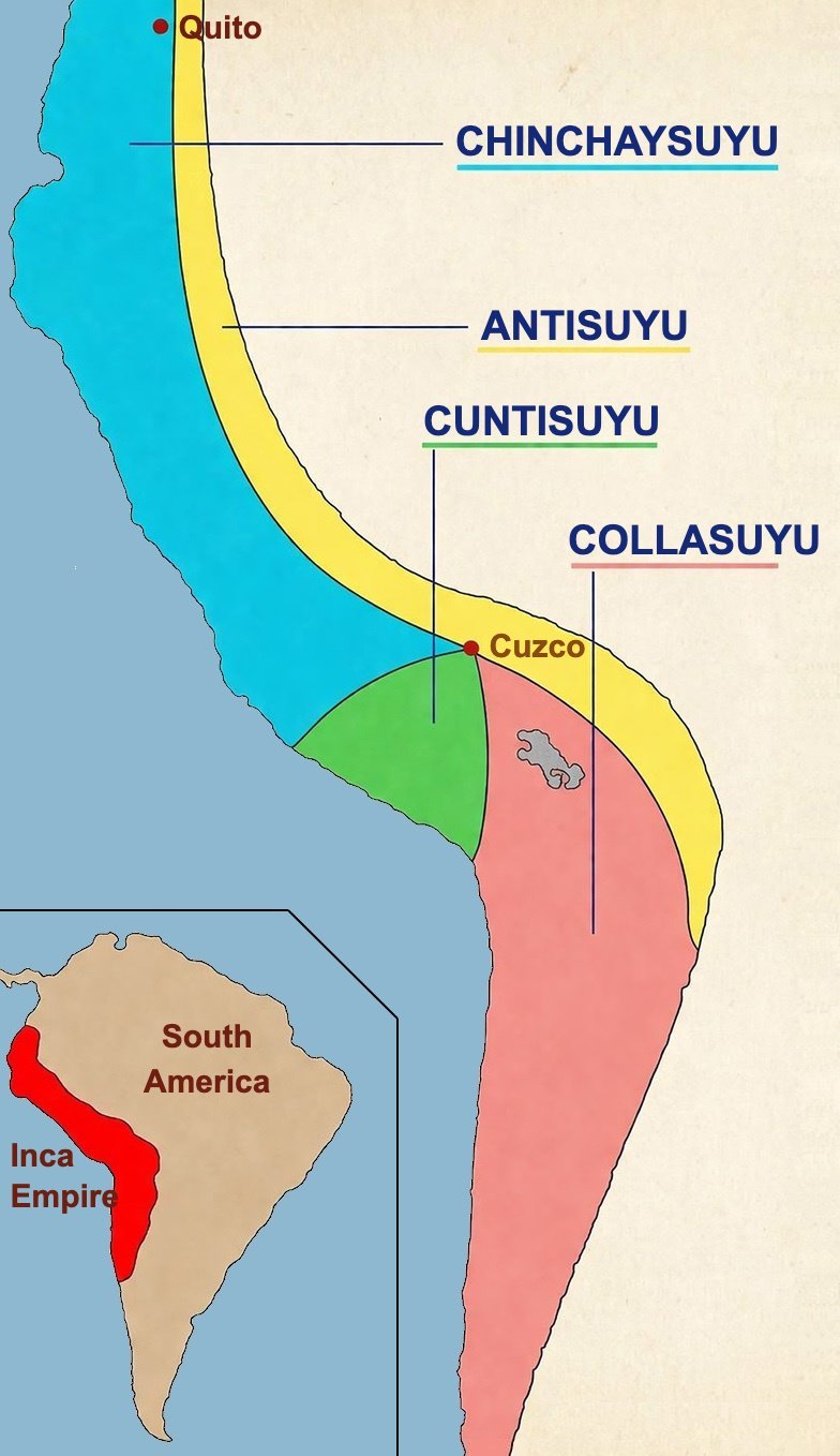
Cuzco
Since our research leads us mainly to Cuzco, let us take a closer look at the geography of the Inca capital.
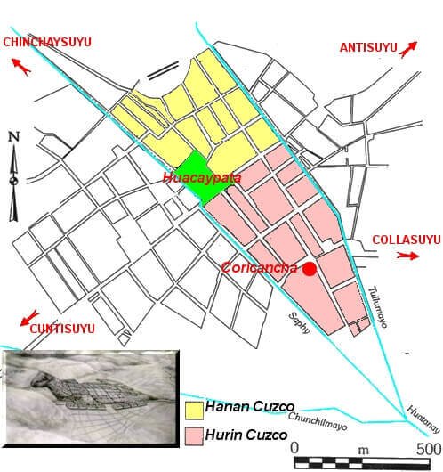
The empire was divided into four quarters (suyus), hence its name: Tahuantinsuyo (the “four quarters”). Cuzco stood at the center of this structure without belonging to any quarter.
The Incas saw in the geographic layout of their city the shape of a puma, their sacred animal (cartouche at bottom left of the sketch above).
The city itself was divided into two quarters: Hanan (upper) Cuzco and Hurin (lower) Cuzco.
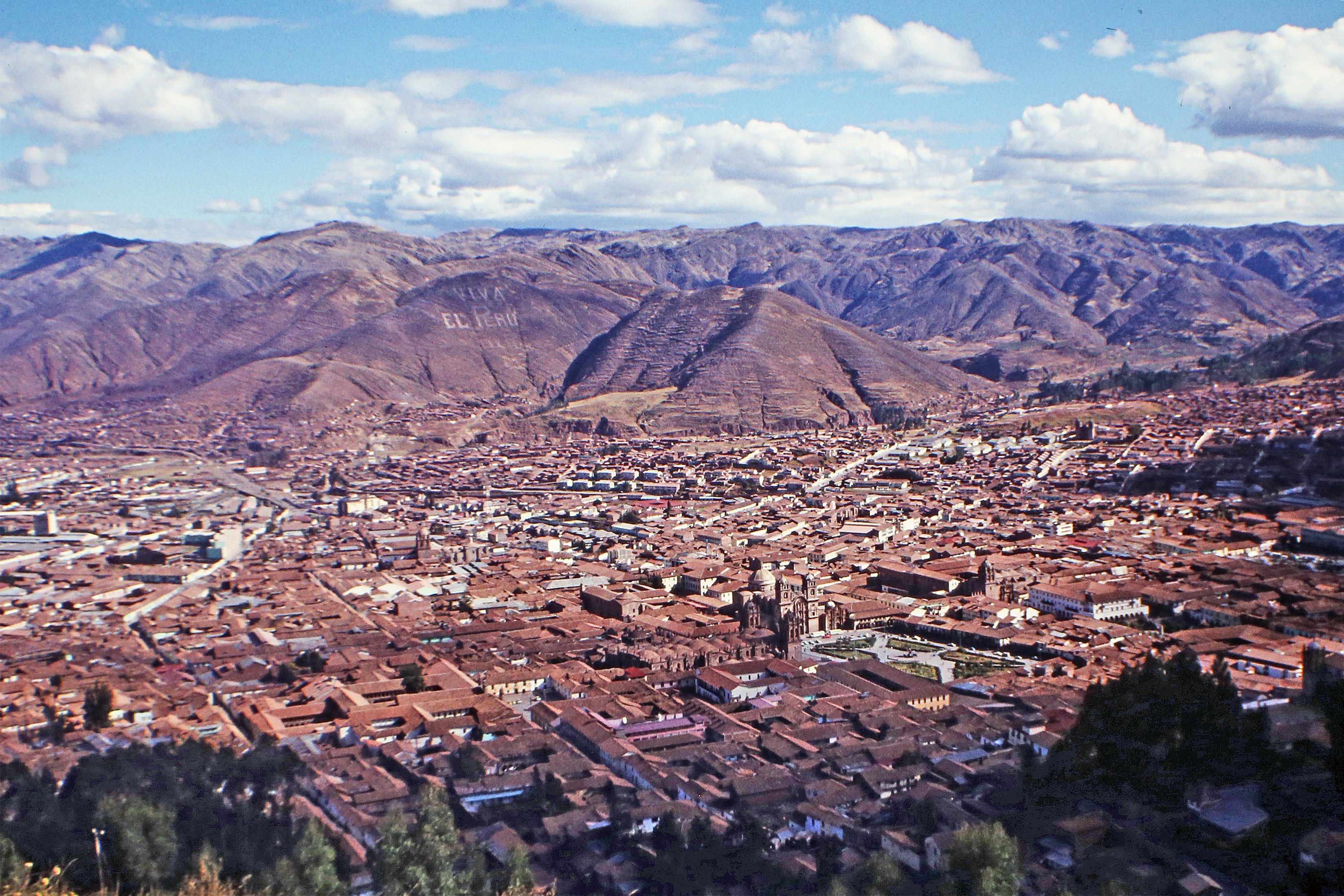
Cuzco's geographic setting was of great importance in building the calendar. It lies in a valley at nearly 3,300 meters altitude. Its coordinates are latitude 13° 54' South and longitude 71° 56' West. At the time of the Spanish conquest, the city had about 100,000 inhabitants.
All these figures matter:
Altitude
At Cuzco's altitude, the sky is particularly clear and well suited to astronomical observations of the Sun, Moon and stars. The Incas certainly practiced these observations, although the mountain environment limited them in duration. Perhaps out of scientific curiosity, but in any case certainly to build an essentially agricultural calendar answering daily questions: when to sow, when to harvest, when to shear llamas.
And, as in any mountain country, the notion of distance gives way to verticality. The key is not how many kilometers separate two places, but how many meters one must climb or descend. This verticality appears in the calendar, in social classes, and in worldview with Hanan Pacha (upper world), Kay Pacha (this world), and Hurin Pacha (lower world). It also appears in Cuzco itself with Hanan Cuzco and Hurin Cuzco, inhabited by people of different social ranks.
Time and space were so interwoven that the term “pacha” referred to both.
Another notion is important: duality. In daily or social life (high and low), worldview (upper world and lower world), and seasons (dry and wet), everything opposes or complements everything else. We will see later that Aveni drew a calendar hypothesis from this.
Latitude
Two points must be noted:
- The Inca Empire in general, and Cuzco in particular, were in the Southern Hemisphere. Seasons are therefore reversed compared with France. On 21 June, for us, it is summer solstice; for the Incas, it was winter solstice. Same inversion for winter solstice and equinoxes. When we speak of winter solstice, for example, we will mean winter solstice in Cuzco.
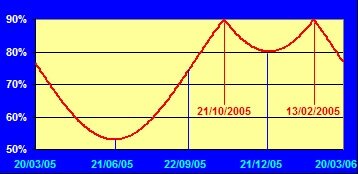
- Cuzco is between the equator and the Tropic of Capricorn. Here too something occurs that we do not experience in France or anywhere outside the tropics: the Sun passes overhead twice a year (never in France), once in February and once in October.
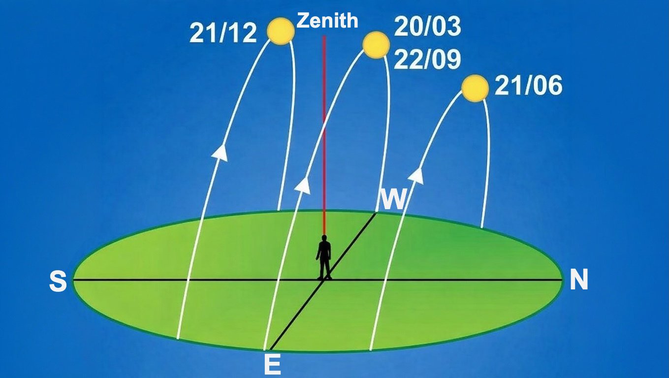
In Cuzco, the Sun's apparent motion.
In Cuzco, the Sun's noon height.
Analysis of the chronicles
As we read these chronicles, we see that the Incas used observation points and landmarks to trace imaginary lines between observation points and sunrise and/or sunset points on the horizon.
These lines must not be confused with the ceque system (more or less straight lines radiating in all directions from Coricancha, Cuzco's Temple of the Sun), which we will examine in the hypotheses section.
All chroniclers agree that the Incas closely observed the Sun's movements and marked some sunrises and sunsets (solstices and equinoxes) with pillars set at various points (most often hilltops on their horizon). To a lesser extent, they also observed and marked the Sun's zenith passage.
Where chroniclers disagree is on where these “markers” were, how many there were, and exactly how they were used.
What is certain is that these observations and horizon markers in Cuzco were less a pure taste for astronomy than a practical necessity tied mainly to agriculture and secondarily to herding. When to plant maize, when to harvest maize, when to plant potatoes, when to harvest them, when to shear llamas... those were the questions Sun observations had to answer.
But let us go into more detail in chroniclers' texts to understand what this “observation calendar,” as Aveni calls it, might have been. And let us first ask whether one can really call it a calendar when its aim is not to count days exactly, but to establish a cycle of agricultural tasks.
Bernabé Cobo's description of the Inca concept of time
Father Bernabé Cobo, in his History of the Inca Empire, explains that the Incas used the Sun's movements to identify years and days, and the Moon's movements to identify months. This would form the Inca division of time: day, month, year. Note that he speaks of the Moon's movement, not its phases.
"They identified our solar year by observing the solstices and beginning the year with the summer solstice, which falls on the 23rd day of December, ending where it began."
The Inca year was therefore a solar year beginning at summer solstice (winter solstice in the Northern Hemisphere) and ending at the next summer solstice. One may wonder what Cobo means by our year. Does he imply this Inca year was a consequence of colonization?
Of course, to begin the year at the solstice, one must know when it occurs. Cobo explains how the Incas proceeded: "On hilltops around Cuzco, two markers or pillars were placed on the east side and two identical pillars on the west side of the city, where the Sun rises and sets when it reaches the tropics of Cancer and Capricorn [read summer and winter solstices] ; and when the Sun rose and set exactly along the southern pillars, as observations were made from Cuzco, that was considered the start of the year. [...] It was when the Sun reached its southernmost point. From there, returning toward the equinoctial line, it passed overhead, and when it moved to its farthest northern point, it rose and set aligned with the two other pillars marking that extreme point; then, returning from there to the point it had left, the tropic of Cancer marked by the first pillars, the year was over."
We find in this description the same pattern shown earlier: two pillars marking sunrise at summer and winter solstices to the east, and two pillars marking sunset at both solstices to the west.
Before pointing out issues raised by this description, let us continue reading Cobo to get a fuller picture of Inca time division.
The year was called huata in Quechua and mara in Aymara. It was divided into twelve months or moons, since the same word designated both (quilla in Quechua and pacsi in Aymara).
Without further details, Cobo writes that pillars were also erected where the Sun rose each month. The set of these pillars, including those marking solstices, was called Sucanta. Pucuy Sucanta were the two pillars marking winter's beginning, and Chirao Sucanta those marking summer's beginning. The months had the same number of days.
How can 12 lunar months make a solar year? Cobo is almost silent on this. He does not explain what this month exactly was and it does not seem based on lunar phases. He only writes that “the remaining days of the year are incorporated into the months themselves.”
Let us now look at month names as given by Cobo and Guaman Poma de Ayala.
But note that after listing month names from different chroniclers, R.T. Zuidema (a leading specialist of Inca civilization) arrives at... 14. This may be because some chroniclers gave several names for the same month, while others gave the same name to a pair of months.
And to add to the confusion, Zuidema notes that the Incas knew (in his view) different kinds of months:
- Synodic months of 29 or 30 days.
- Solar months of 30 days.
- Sidereal months of 27 1/3 days.
- Months of 23, 24 or 26 days.
| Month no. | Month name | Approximate correspondence | Description | |
|---|---|---|---|---|
| Cobo | Guaman Poma de Ayala | |||
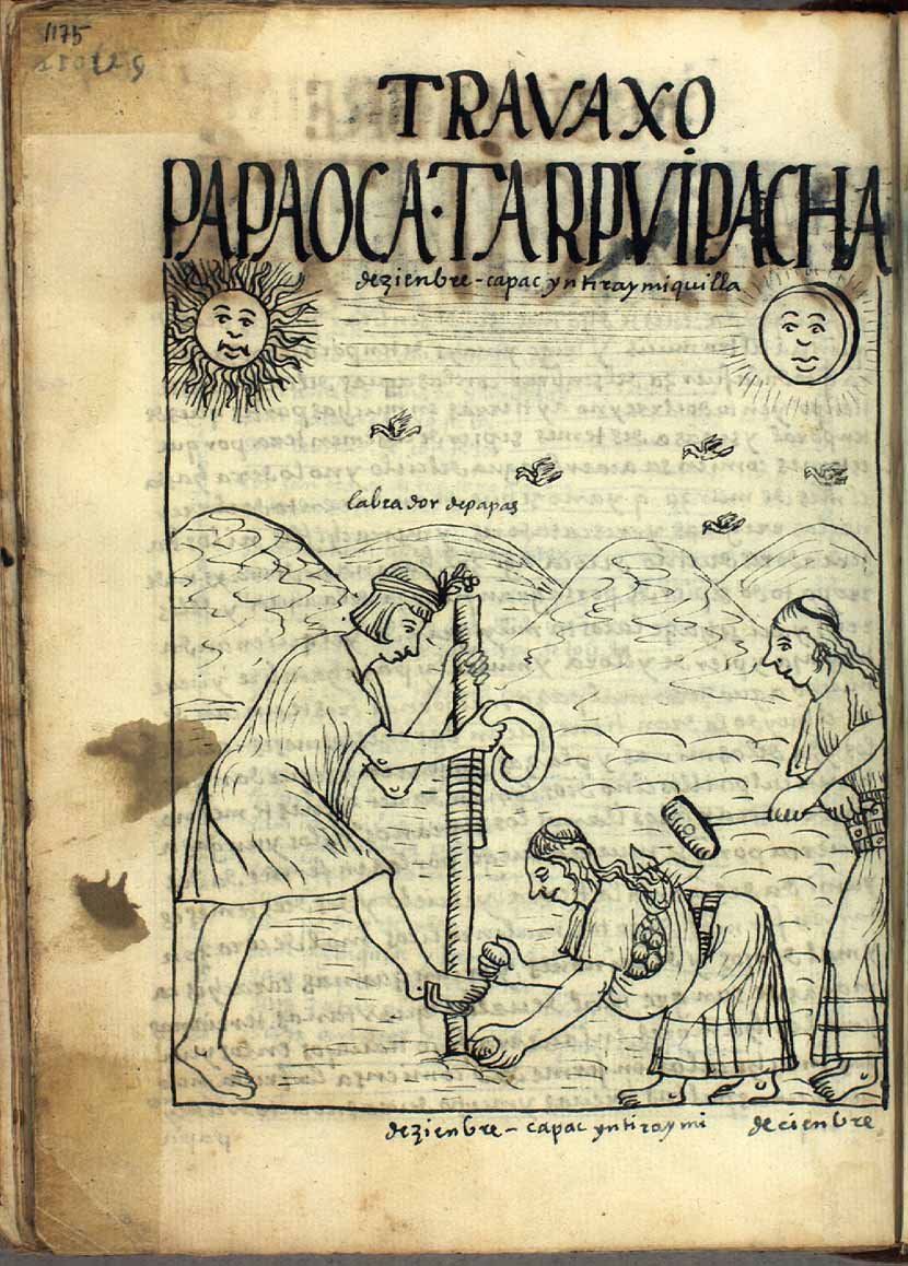
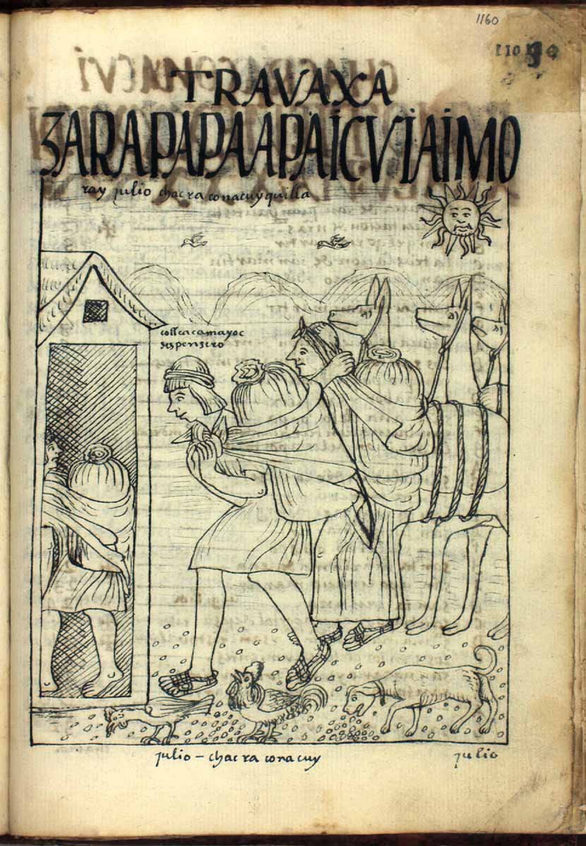
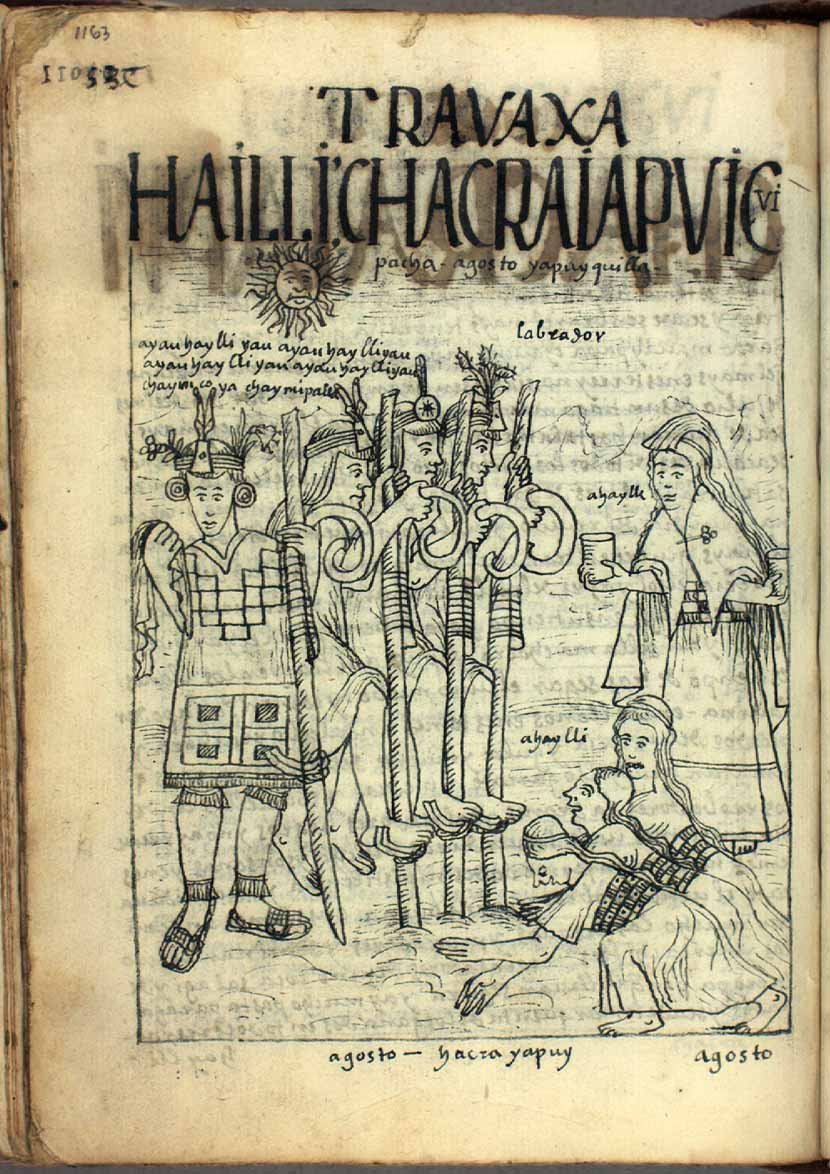
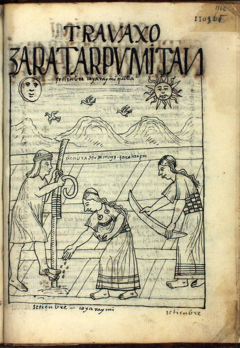
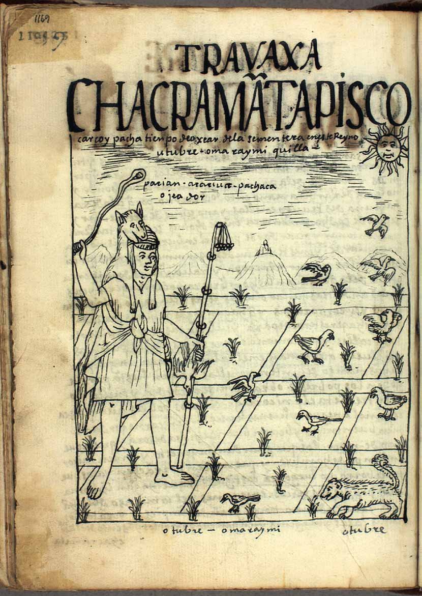
| 1 | Raymi | Qhapaq Inti Raymi Killa | December | Month of Sun festivals Potatoes are planted |
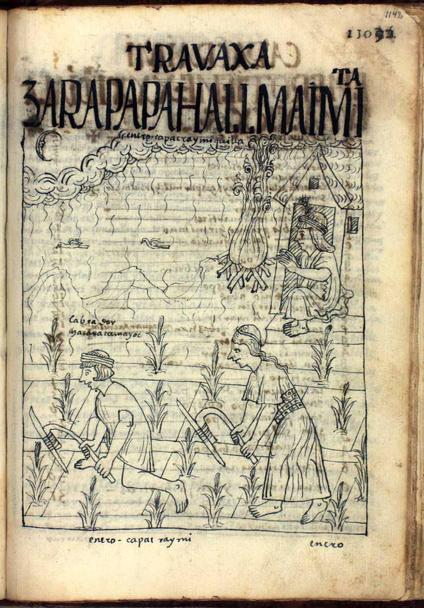
| 2 | Camay | Qhapaq Raymi Killa | January | Month of the great festival Maize, rainy season and ploughing |
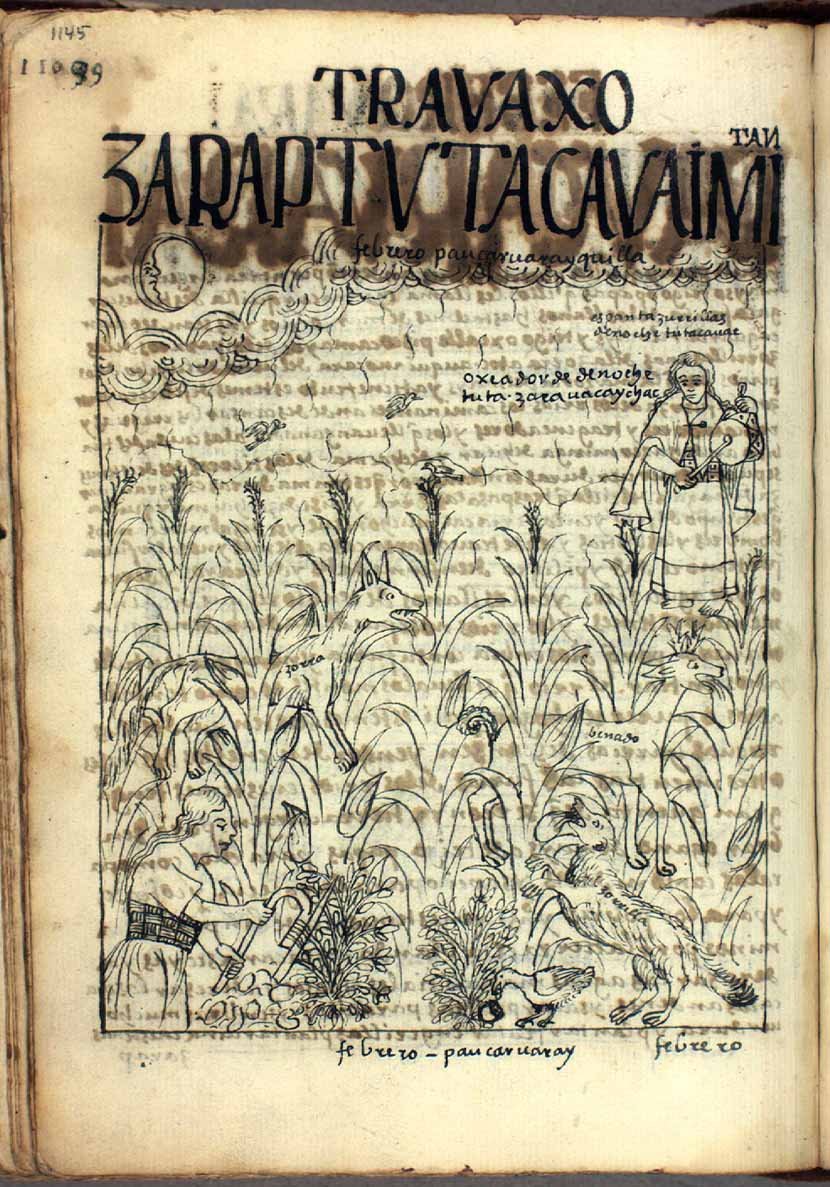
| 3 | Hatun Pucuy | Pawqar Waray Killa | February | Month to wear loincloths Night watch over maize |
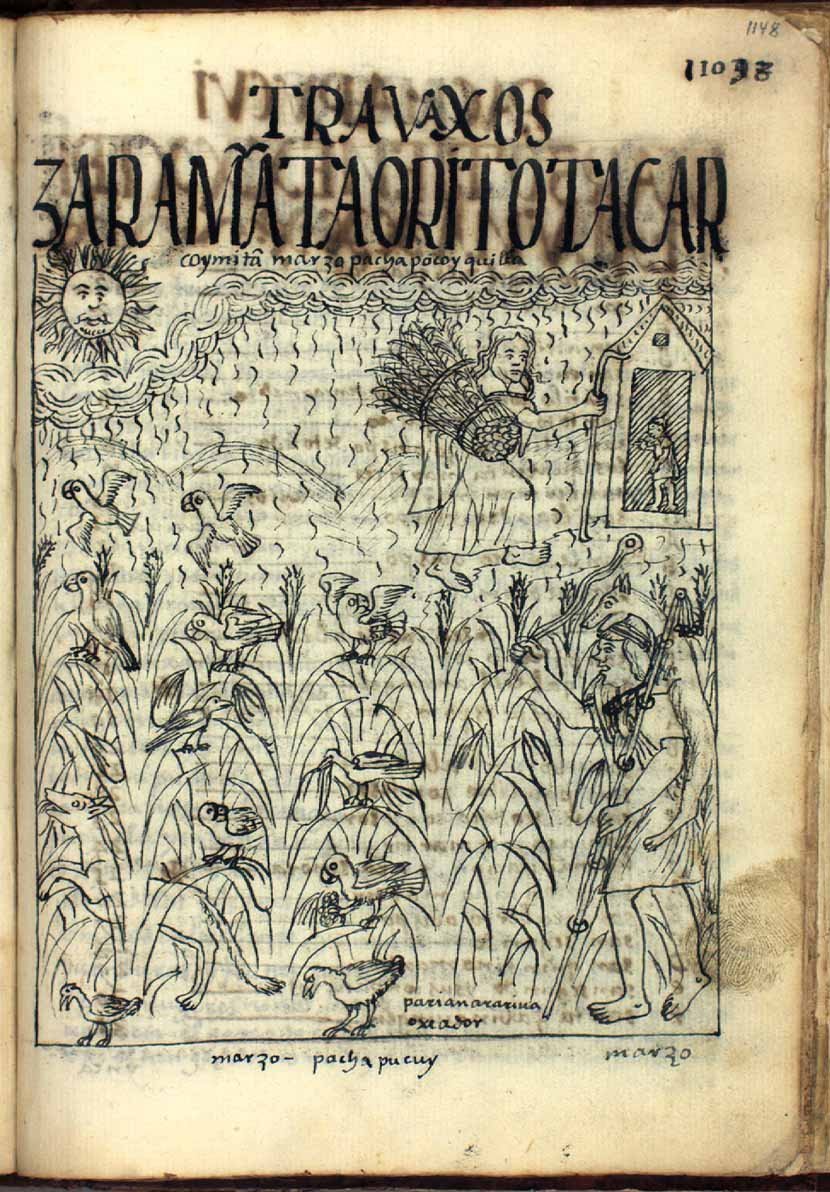
| 4 | Pacha Pucuy | Pacha Puquy Killa | March | Month of soil ripening. Drive birds away from maize fields |
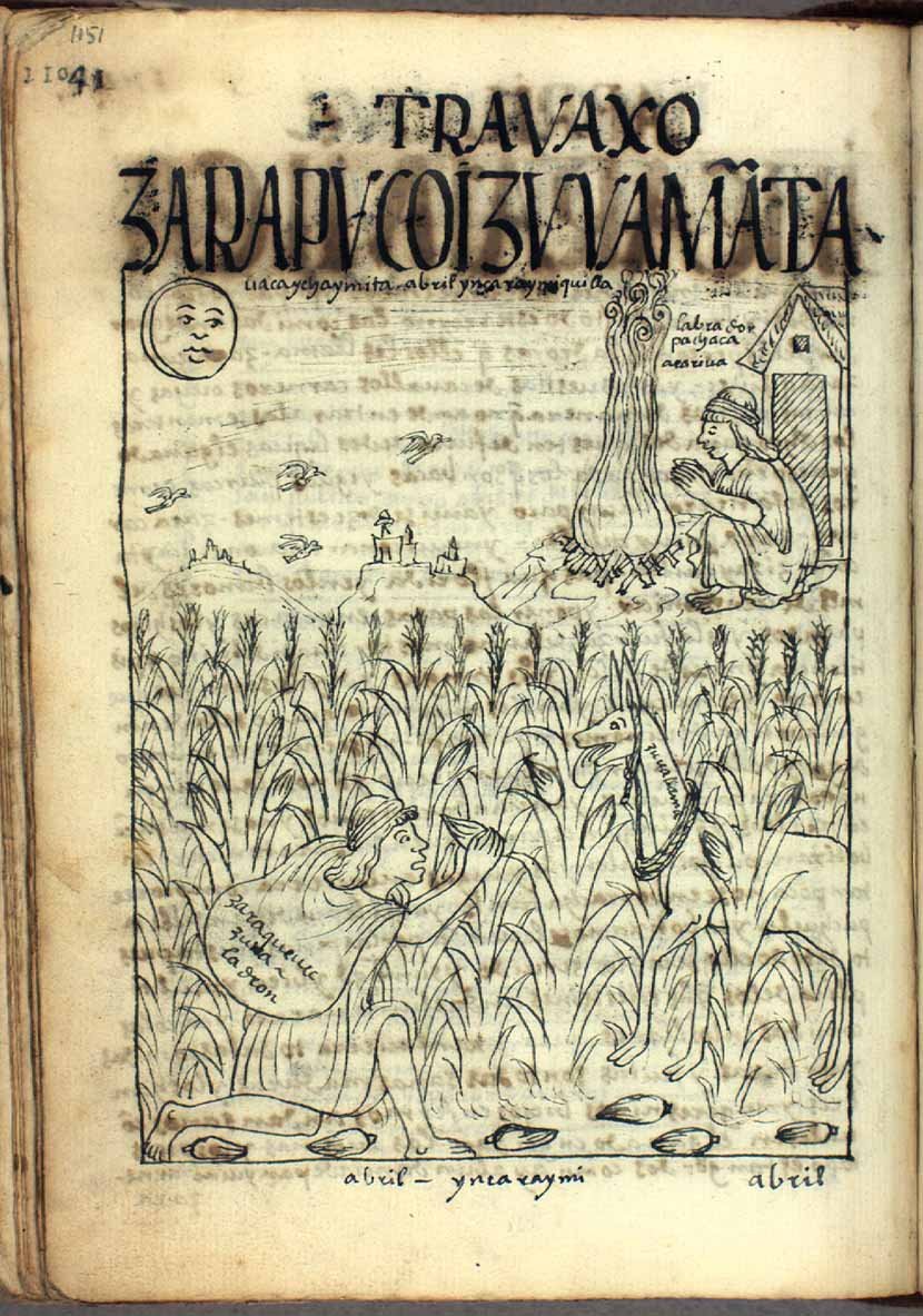
| 5 | Ariguaquiz | Inka Raymi Killa | April | Month of the Inca festival Maize ripening |
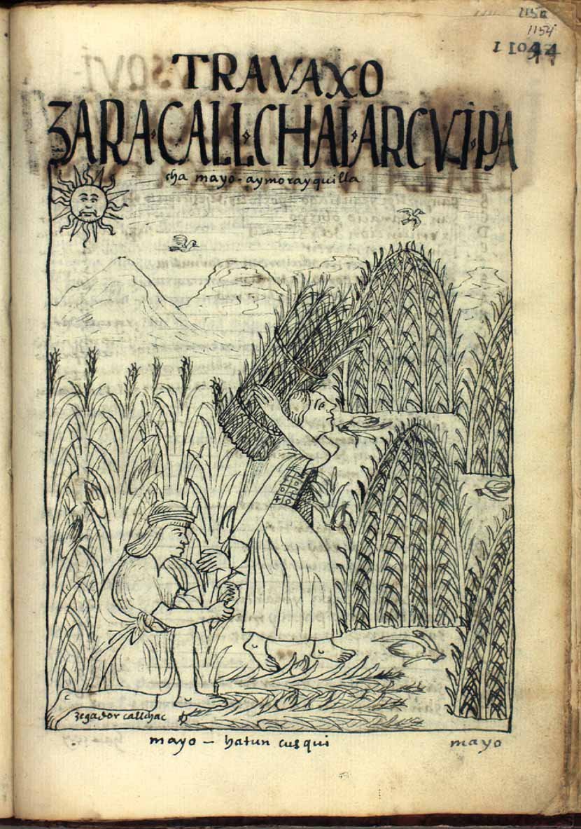
| 6 | Aucay Cuzqui Aymoray | Aymuray Killa | May | Harvest month. |
| 7 | Aucay Cuzqui Aymoray | Hawkay Kuski Killa | June | Rest month after harvest. Time to plant potatoes |
| 8 | Chahua Huarquis | Chakra Qunakuy Killa | July | Month of land distribution. Store maize and potatoes |
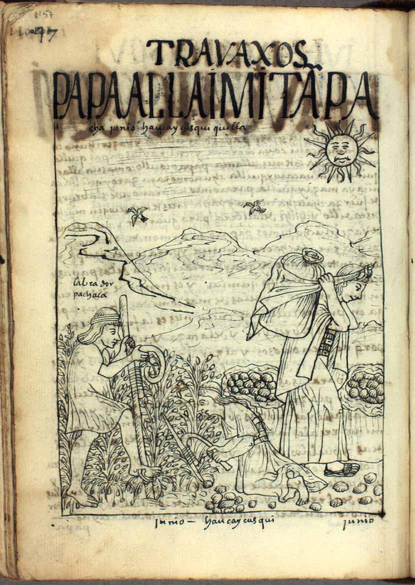
| 9 | Yapaquis | Yapuy Killa | August | Ploughing month. |
| 10 | Coya Raymi | Quya Raymi Killa | September | Month of the Queen's festival (quya). Maize is sown |
| 11 | Homa Raymi Yapaquis | Uma Raymi Killa | October | Month of origins festival. Protecting the kingdom's fields |
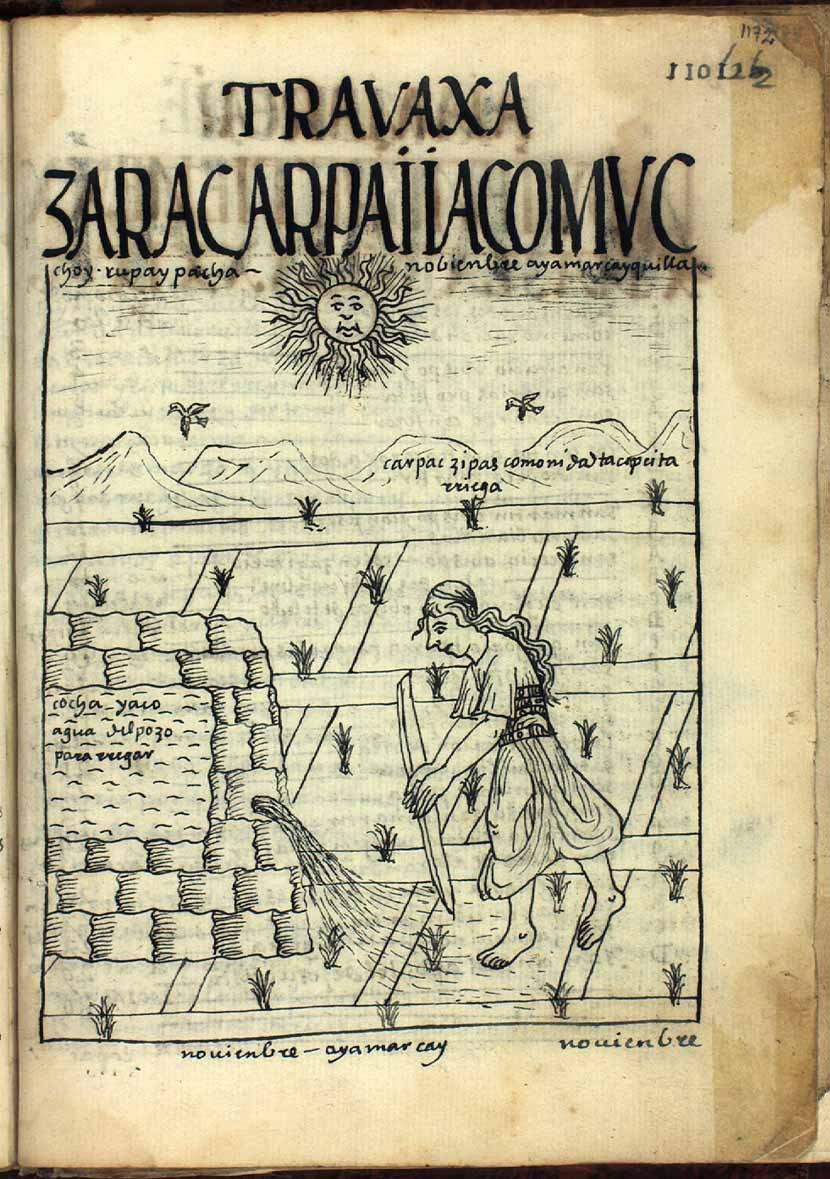
| 12 | Ayamarca | Aya Marqay Killa | November | Month for carrying the dead. Watering maize. |
And Guaman Poma de Ayala's illustrated representation of these months (click thumbnails to enlarge):
Cobo explains that these months were meant to regulate sowing and ploughing periods and to mark ceremony dates. And, he adds, “for nothing else”. There was no year count, and Incas did not know their age in years. They did not divide the year into units other than days and months. To indicate when they had begun some work, they pointed to the spot in the sky where the Sun stood at that moment.
Contrary to what Cobo says, it seems the Incas did know an eight-day “week”. It appears in market cycles, in priest service periods at Cuzco's Temple of the Sun, and in the royal custom of rotating women in service.
The issue of Cobo's marker pillars
It is well known: through two points, only one straight line can pass. If one point is a pillar, where is the other so that this imaginary line points to sunrise (or sunset) on the horizon? If we stick to Cobo's account, that point is in Cuzco - naturally at Coricancha, the Temple of the Sun, center of the ceque system we will discuss later. Is that correct?
Anthony Aveni, who studied the issue, answers as follows:
Cobo places one pair of pillars on Cinchincalla hill (3rd huaca of the 13th ceque of Cuntisuyu). He writes that when the Sun reaches them, it is time to plant.
By “sighting” these pillars from Coricancha, one indeed finds that the Sun aligns there at the December solstice.
It should be noted that Cobo likely made a mistake in saying it was planting time, since it was rather harvest time.
And for the June solstice? Here, unfortunately, things become more complicated.
According to Cobo, the marker pillars were on Quiangalla hill (9th huaca of the 6th ceque of Chinchaysuyu).
But Aveni notes that Quingalla is not visible from the city, and therefore not from the Temple of the Sun. So is the whole solstice sightline theory wrong?
No - what is wrong is the observation point. Aveni establishes that the observation point for the June solstice was in fact another Temple of the Sun at Chuquimarca, described as such by Cobo.
Aveni also adds that the probable observation site for the December solstice was rather at Puquincancha, another Temple of the Sun south of Cuzco. This shows we must not confuse the ceque system with the transverse imaginary lines created by observing the Sun at solstices, even if some pillars and/or observation points do lie on huacas belonging to ceques. Not simple, right?
In this dual observation system - northern for sunset at the June solstice in Hanan Cuzco, and southern for sunrise at the December solstice in Hurin Cuzco - Aveni sees the result of the Inca dualist worldview, in which people of the empire's northern and southern halves each “guarded” one part of the year.
From Cobo's writings and Aveni's observations, one can draw a map of Sun observation lines at key moments of the year. This map contains other data we will return to.
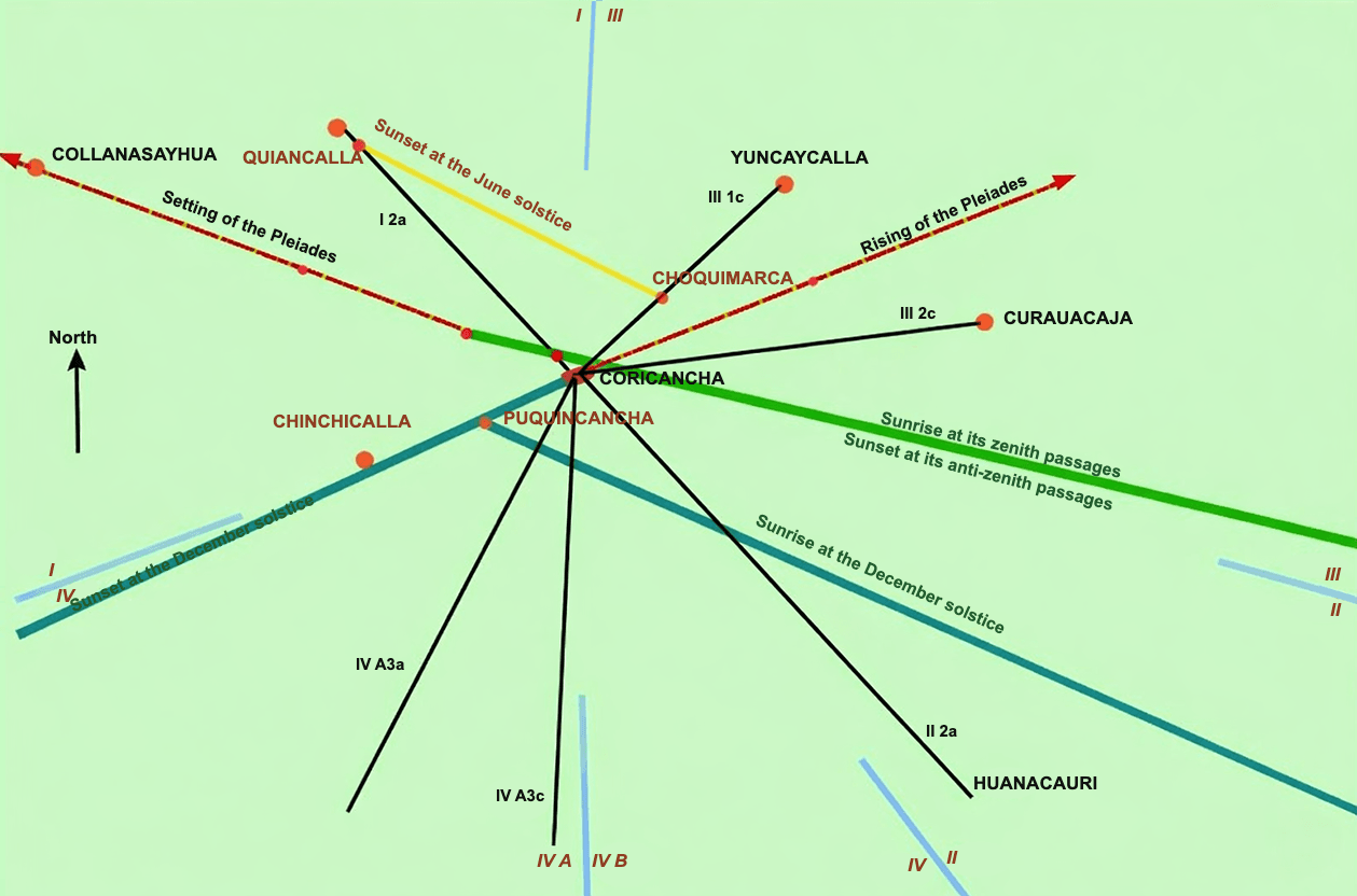
The green, yellow and turquoise lines are imaginary lines pointing to the Sun on the horizon at different times, passing through one or more pillars from an observation point.
Pillars: where? how many? how used?
On this topic, one can read everything and its opposite - without invalidating the observation system itself. And since these pillars were destroyed by Spaniards, who saw their sites as places of idolatry, each of us can now only form a personal opinion as far as the described principle appears workable.
Pedro Sarmiento de Gamboa (1532 - 1602), Spanish writer, historian, astronomer and scientist, writes in his History of the Incas that "to know the precise times for sowing and harvesting, the Inca had four posts erected on a high mountain east of Cuzco, spaced about 2 varas apart [1 vara = about 91 cm], with holes at the top through which the Sun entered like an astrolabe. By observing where sunlight touched the ground through these holes at sowing and harvest times, they made marks at those places. Other posts were erected on the side west of Cuzco for maize harvest time. Having fixed positions exactly from these posts, they then permanently built stone columns in their place, with the same height and holes in the right spots. They ordered paving all around. And on the stones, certain lines were drawn according to the sunlight passing through the holes. [...] People were assigned to observe these dials and signal to the people the times they indicated."
In his translation of Sarmiento de Gamboa's work, Clements Markham adds a note about pillars: "Acosta says there was one pillar per month. Garcilaso de la Vega says there were 8 east and 8 west of Cuzco, in two rows of four, two small between two large, separated by 20 feet [about 610 cm]. Cieza de Leon says they were in the Carmenca quarter. To determine equinox moments, there was a stone column in a square before the Temple of the Sun, at the center of a large circle. This was the Inti-huatana (circle of the Sun). A line was drawn east to west, and they observed when the pillar's shadow lay on the sunrise-sunset line and when there was no shadow at noon. There was another Inti-huatana at Pisac, and another at Hatun-colla [on Lake Umayo near the western shore of Lake Titicaca]."
I don't know what you think, but for my part, I give up trying to answer where, how many and how. What matters, in the end, is having established that the Incas used a solar calendar of orientation type (a bit like what we now call orientation tables), agricultural in purpose (and perhaps religious), regulated by solstices and equinoxes.
When does this solar year with pseudo-lunar months date from?
The only one to give a brief explanation seems to be Father Sarmiento de Gamboa, who writes in his History of the Incas that “he ordered the year to be divided into twelve months.” The he in question being Pachacuti Inca Yupanqui, one may infer that this “invention” dates from the end of the 13th century.
Hypotheses
We have seen that some places belonged to the orientation calendar system, either because they served as observation points or because they were the places “sighted” from those points.
Most of these places were huacas belonging to the ceque system.
Beyond this observation-calendar role, Aveni and Zuidema think the whole ceque/huaca system also functioned as a calendar in the modern sense: a day-counting system for the year. Zuidema speaks of a “string of beads”: one would count days by moving through huacas like beads.
The ceque system
From Cuzco, a system of 41 directions, the ceques, radiated toward different horizon points. Along each ceque were sacred places, huacas, which could be simple stones, springs, trees, or other objects. According to B.S. Bauer, they can be grouped into categories.
| Type | Number of huacas | Percentage |
|---|---|---|
| Springs or water points | 96 | 29% |
| Standing stones | 95 | 29% |
| Hills and passes | 32 | 10% |
| Palaces and temples | 28 | 9% |
| Fields and open areas | 28 | 9% |
| Tombs | 10 | 3% |
| Ravines | 7 | 2% |
| Others: stones, solar markers, caves, trees, roads and paths | 16 | 5% |
| Unclassified | 16 | 5% |
| TOTAL | 328 | |
One should above all not imagine huacas were evenly spaced along ceques, that ceques were straight roads drawn around Cuzco, or that each ceque had the same number of huacas.
In fact, the ceque/huaca system looked like a huge quipu, with knots (the huacas) in varied numbers on twisted cords.
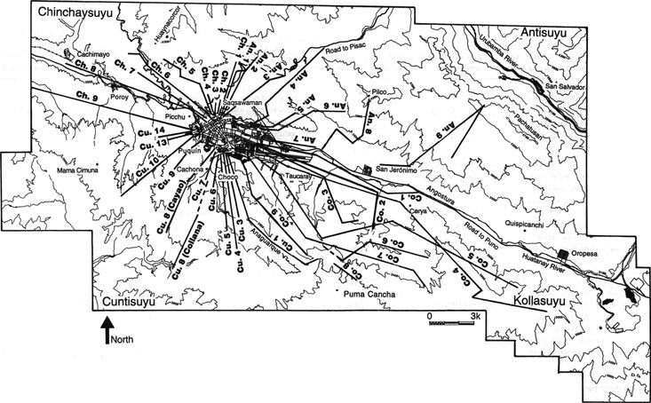
The ceque system radiating around Cuzco from the Temple of the Sun. This image can be compared with the quipu shown above.
We owe a precise description of huacas and ceques to Bernabé Cobo, who codified them as follows: first two letters of the suyu, ceque number, huaca number. We know the four suyus (quarters of the empire) were Chinchaysuyu, Antisuyu, Collasuyu and Cuntisuyu. So, for example, CU-2:2 is the second huaca of the second ceque of Cuntisuyu. Each huaca had its own name, and each ceque too.
Based on Cobo's description, and to build his calendar hypothesis, Zuidema recoded huacas differently: suyu (I, II, III, IV; with suyu IV split into two sub-suyus IV A and IV B), group of three ceques (1, 2, 3), and individual ceque (a, b, c). He does not give huaca number. Thus, for example, Cobo's CU-2:2 above becomes Zuidema's IV B 2 c, but CU-2:3 would have the same reference.
We will not detail all ceques and huacas here, as that would break the flow of calendar analysis itself. For those interested in names and Cobo/Zuidema concordances, it is here.
We will also set aside Zuidema's hypotheses, to which we may return one day in a dedicated study. They are complex and deserve a page of their own.
And we will examine Aveni's hypothesis, which acknowledges the limits of our knowledge of the ceque calendar system. Our goal is less to understand how this system could constitute a calendar than to know in what order each huaca was visited each day.
Cobo, for his part, merely described huacas and never once suggested this system might form a calendar.
The ceque/huaca calendar according to Aveni
So we have 41 ceques and 328 huacas. What can we do with that? It is still far from the 365 days of a solar year.
Except that 328 = 41 X 8 = 27 1/3 X 12.
So what?
1) Well, 41 is the number of ceques and 8 is the number of days in an Inca week.
2) And 12 is the number of months in a year, while 27 1/3 is the duration of a sidereal lunar month.
And the 37 missing days?
According to Aveni, they corresponded to a period of Inca inactivity. It also roughly matches the time between heliacal setting of the Pleiades (3 May before the Spanish conquest) and their heliacal rising (9 June before the conquest). From heliacal rising onward, the Pleiades spend longer in the night sky, as day length increases; climate gets warmer. Then Pleiades presence decreases as days shorten and climate cools. Their absence from the sky would therefore match a natural inactive period. We already mentioned these "forgotten days" when discussing the Inuit calendar.
In conclusion
We still have much to discover about the Inca concept of time. The lack of writings does not help.
Admittedly, the ceque-calendar system may seem somewhat far-fetched. But it should not be viewed as an isolated entity. It belongs to a total and complex Inca worldview. As Aveni writes, "they sought to shelter all activities of the universe under an ideological umbrella made of space and time. The ceque system is neither image nor representation: it IS Tahuantinsuyu [the empire of four quarters] itself."